Bang Kachao is often called Bangkok’s green lung. Surrounded by the Chao Phraya River, the area remains one of the city’s most important green spaces despite being close to dense urban development. However, Bang Kachao also faces environmental pressures, including saline water intrusion and changes in vegetation coverage.
This project, developed by Thanakit Jianwanalee, explores how open-access satellite imagery can support environmental monitoring for green communities. The project focuses on two questions: how satellite radar can help monitor water-level patterns, and how multispectral imagery can track green-area changes over time.
The study uses Sentinel-1 Synthetic Aperture Radar data for water-level analysis. Unlike optical satellite imagery, Sentinel-1 uses radar signals and can capture data even at night or through cloud cover. This is especially useful in tropical regions such as Thailand, where cloud coverage often limits optical imagery.
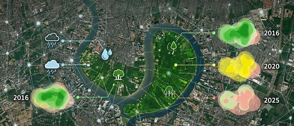
The project also uses Sentinel-2 multispectral imagery to analyze vegetation coverage. By calculating the Normalized Difference Vegetation Index and Normalized Difference Built-up Index, the workflow classifies pixels as vegetation or non-vegetation and estimates green-area coverage across different years.
The analysis compares Bang Kachao’s green coverage in 2016, 2020, and 2025. The estimated vegetated areas were approximately 9.66 square kilometers in 2016, 9.37 square kilometers in 2020, and 9.53 square kilometers in 2025. These results suggest a slight decrease in 2020 followed by partial recovery in 2025, though the project notes that seasonal effects and image conditions may also influence the results.
For water-level monitoring, the project found a negative relationship between Sentinel-1 radar backscatter intensity and water level. This suggests that radar imagery can provide useful supplementary information when combined with ground-based measurements.
The project demonstrates how freely available satellite data can support local environmental monitoring, especially in communities where long-term ground sensors may be limited. It also shows how AI and engineering students can apply remote sensing tools to sustainability and urban resilience challenges.